


Rhena on the move – Part 6
From Rheinau to Buchberg, Kirche

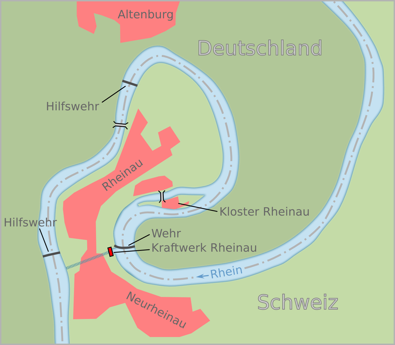
Welcome back everybody! Remember when I said that Evelyne wasn’t going to walk that look around Rheinau? I love when I’m right. That loop is about 4.4 kilometers long and cutting across is about one tenth of that. Yes, there are things that you miss. There is a monastery on an island in the river and there’s also a beautiful old bridge, but here’s what really happened.
The water level is quiet high from the Rhine Falls to Rheinau and I just found out why. There was another one of those barriers, but I wasn’t going to fall for that one again. I stayed well left – basically away from Germany and you know what suddenly happened? I got sucked into the powerplant, raced through a turbine again and was spat out the other end. They were hiding it to the left. There was a secret entrance to a canal under the town. I ended up taking the same shortcut I knew Evelyne would take. I didn’t mean to, but there you go.
I’m still really mad that nobody told me. I was crying when I got out on the other side. How is this fair? I then met a few friends, and they told me that it took them like FOREVER to navigate the loop. There were several barriers (called “Hilfswehr” on the map). These were apparently their as dams of sorts, so the river doesn’t dry up. Ever since the power plant was opened only a fraction of water flows through the loop. Putting in those barriers ensures that water levels remain high enough for waterfowl and to keep the monastery on an actual island. Apparently, that’s important. The way electricity is generated is by using the gradient between the water level east of town and the water level west of town. There is a difference of between 7.86 und 12.52 meters. So, I got to the other side on a foggy summer morning. I really needed that. It was so nice and peaceful just floating along.

Until the loudest bell EVER tore me away from that peaceful moment. What’s going on?! Well, I tell you what was going on. Evelyne decided to just randomly hop on a ferry across the river and walk on the other side. That was clearly not the official route [add link], but it looked shorter. Of course on the map it also looked like there was a bridge of sorts since the hiking route goes right across. Turns out, you have to ring a bell to alert the ferryman to your presence. Operating hours are from 9 to 5 with a one hour lunch break. The ferry takes you across into Germany. The border is that purple-ish band on the map. You’re just in Germany for about 100 yards or so. This makes it an international ferry – that makes me smile. The ferry was first mentioned in 1500 and is part of the inventory of historical transport routes in Switzerland. The area was tax exempt for a while in the 19th century. The border was just too complicated and too long to patrol.
Anyway, I heard Evelyne talk to the ferryman. She does ask dumb questions sometimes. The ferry was obviously attached to a cable, there was no motor and the ferryman used the current to navigate across. Pretty basic physics really, but yes, the question of how this works had to be asked … come on! It’s not rocket science. Well, the ferryman was nicer than I’d have been, explained how it worked and how depending how he angled the boat it went faster or slower. I loved the no motor aspect of this ferry. Motors are loud in the water. Lovely ferryman, even though he had to get on his bike and come especially to take just one person across. The ferry is not free – it costs CHF 4.50. Well worth it! There are several ferries across the Rhine that form part of the official hiking network. The system is always the same – ring a loud bell and wait for the ferryman. If you want to use them, check if they are in operation.

On this occasion if you don’t dare ring the bell or the ferry is not running, it would just mean a little detour and that’s usually the case. You won’t get stuck. If we look at the map again you can see the that route 60 is a bit longer. There’s a lovely nature reserve and if you haven’t walk there before you should definitely do it. The hiking route also leads right through a campground later on. Route 60 is a fun route.
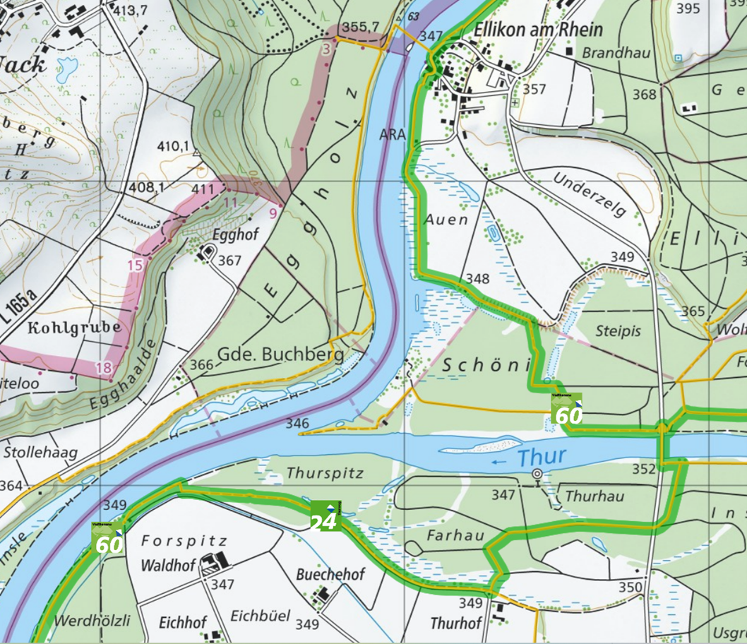
Now, let’s talk about the not so fun bit. You see those letters A-R-A in the middle of the river. They come up a lot! Like every few miles. You want to know what they stand for? It’s Abwasserreinigungsanlage – that’s German for waste water treatment plants. Now, while I applaud the Swiss for being so good with treating water and making it safe to go into the river after, that water is traumatized when it arrives back. I don’t think I have to spell it out to you. At least they get cleaned in the end. I’m sure you know the experience that when you touch something gross or get something on you that it takes quite a while to feel properly clean again. Now imagine bathing in said thing. You get the picture.
We try to be supportive of course and hope we’re never taken out of the water to go on that particular journey, but you never know. It could happen to every single one of us at any point. Best not dwell on it too much.
I was really glad that somebody had warned me about the beavers and about the Old Rhine. It’s right next to the Rhine but it doesn’t flow much. An excellent place to retire to. Just not for me. I’m ready for more adventures. The route to the west of the Rhine joins the official route in Rüdlingen, where there is another ARA and the route takes a shortcut right past it. There are public toilets there – of course there are. Moving on. The route goes up into the hills. There are a lot of vines, big vineyards covering the entire hill and there’s a church on top. Quite a pretty one.

Sometimes you can hear hiker swear from all the way down in the water. It is a really steep climb. Pretty much straight up. Oh, and if you’re wondering what that purple line in the middle of the river is, that’s just the border between canton Zurich south and east of the Rhine and canton Schaffhausen to the north and west.
This is where I leave you. Here’s a video of this stage. See you again soon in Eglisau.
Notes:
https://upload.wikimedia.org/wikipedia/commons/e/ea/Lageplan_Rheinau.png
https://de.wikipedia.org/wiki/Kraftwerk_Rheinau#
YouTube Video
https://de.wikipedia.org/wiki/Rheinf%C3%A4hre_Ellikon%E2%80%93Nack
https://de.wikipedia.org/wiki/Jestetter_Zipfel
Official route:
https://schweizmobil.ch/en/hiking-in-switzerland/route-60/stage-5
Delightful that there is a monastery on an island in the river so the folks that monitor water levels must take care not to flood it. Lovely scenery all around. The ferry boat is smaller than expected but for one passenger, fine! Video very nice, too! PS I still want to live in Switzerland! 😘
Love the ferry and the bell! A beautiful water taxi with an international flair.