


Hiking in Switzerland
A bit more on hiking in Switzerland.

The Swiss are hikers
I’ve already written about why I love hiking / walking in Switzerland but now that I’m walking across Switzerland I’ve decided to add a bit more information. Let’s start with some numbers. Of the Swiss population aged 15 or older, 58% hike on a regular basis. That’s a lot of hikers. So, it makes sense that there are 50,000 signposts and 65,000 km of hiking paths (this compares to 71,400 km roads). Being a country of hikers, we sort of assume that people who hike here have a basic understanding of what hiking is and what it entails.
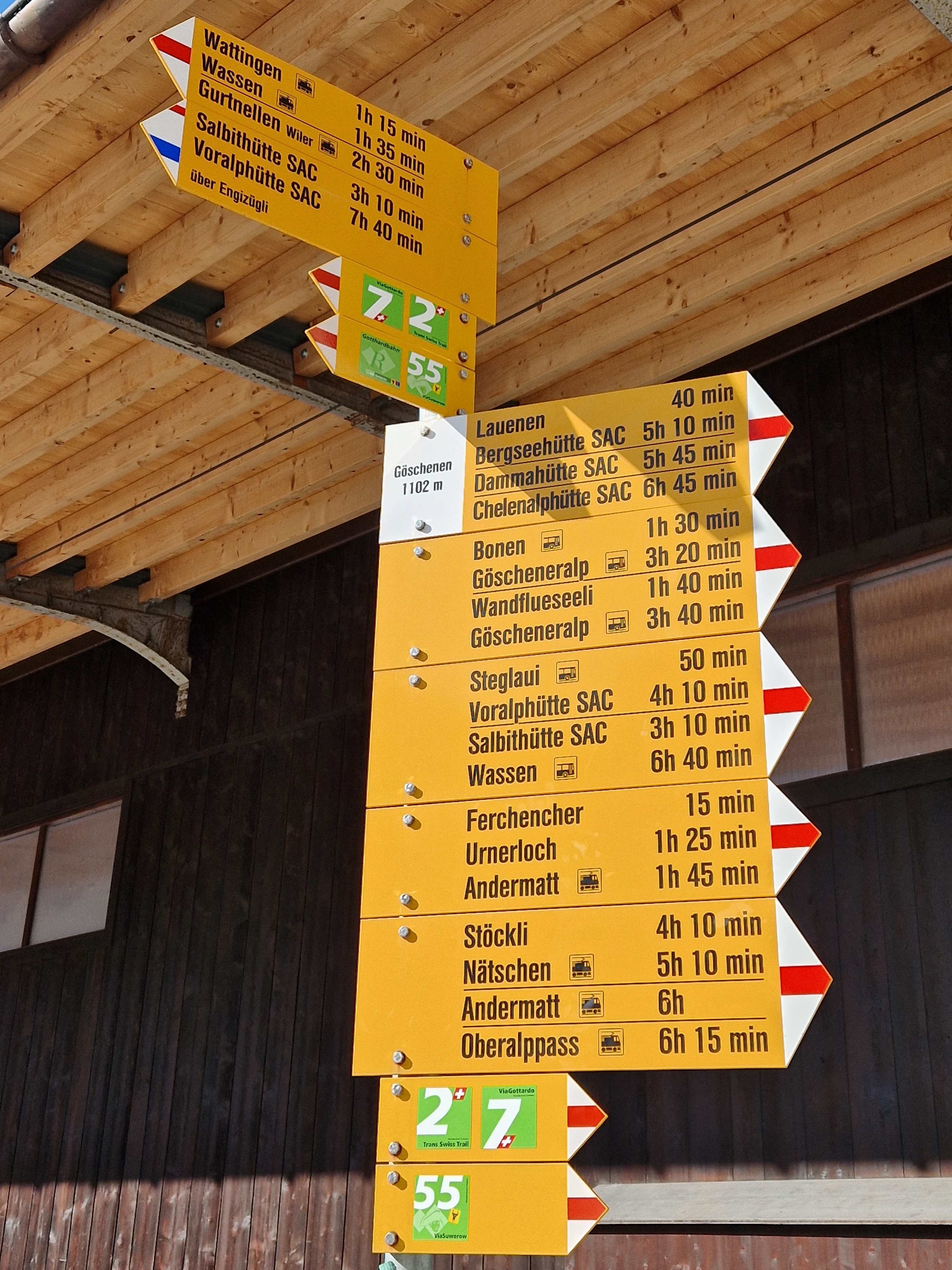
Let’s look at one of the signposts. You have a white square that tells you where you are and what the elevation is. This might not be as important in other countries, but in Switzerland this is important. How else would we brag about the elevation gain in our hikes? The white numbers on green ground are special routes. I’m currently following route 7 from Basel to Chiasso. Of course you have the destinations as well. Sometimes there are different routes to get to the same place. In my case I was hiking up towards Andermatt and I went for the 1h 45 route rather then the 6h one. What you can also see is that most routes drop you off at a train station or bus stop. This is something that’s very nice around here. See my other newsletter for more about public transport and hiking. The ones where it says “SAC” – those are huts / cabins provided by the Swiss Alpine Club where you can spend the night or have a break. They also offer shelter should the weather change unexpectedly.
Moving on to the horizontal lines. Those mean that the route will split at some point. So, you need to pay attention not to miss the turn off. Where I usually walk down here there are no white/red/white or white/blue/white markers. We only have regular hiking routes. The red ones are mountain hiking routes, and the blue ones are Alpine hiking routes. More on those below.
Hiking time
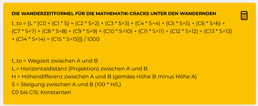
I did get some questions about the hiking time that’s indicated. Here’s what I found out: historically every canton (state/province) had people walk their routes and they averaged the times. That’s why hiking times indicated could vary greatly between cantons. Some sent very diverse groups of hikers on their way others very fit ones (at least that’s what the “slower” cantons were saying). The average hiking time on a flat path is usually 4km/h. There’s a formula that takes distance, gradient and elevation gain/loss into account. We all have different walking speeds but knowing that this formula is standardized will help you figure out if you’re faster or slower than average. I’m slower when it’s flat, but about average uphill and very slow downhill. Here’s the formula for those who’re interested.
Types of routes
Regular hiking paths – yellow markers – can be walked in regular, but good walking shoes. No boots required. I would still wear hiking boots if you’re heading into the hills, but that’s just common sense. Now, when it comes to mountain and Alpine routes, I’m not an expert on those. Check out what the Swiss Alpine Club says about the different routes. They are the experts here.
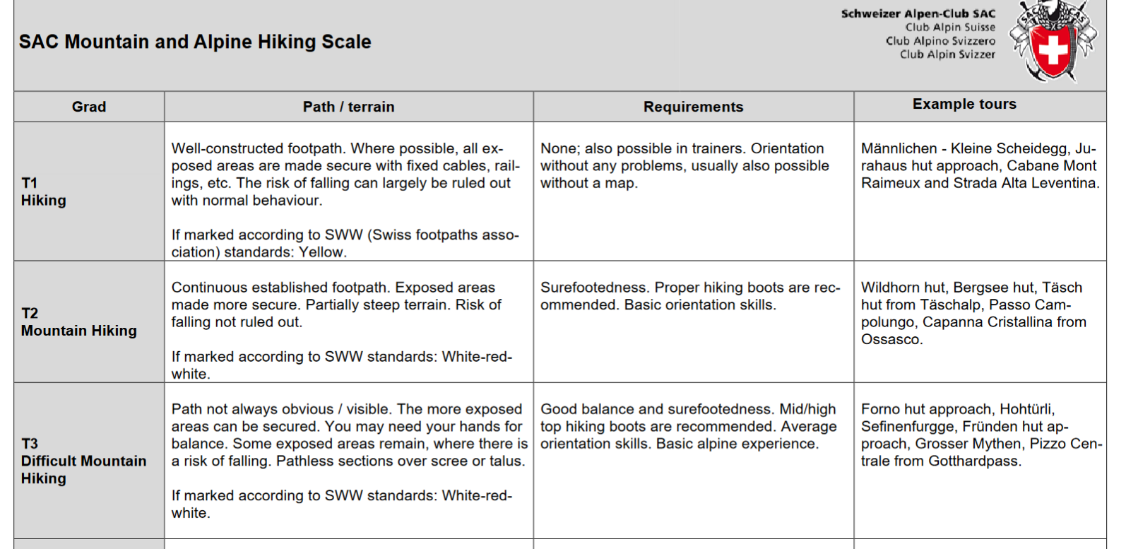
I’m very comfortable walking along T1 or T2 routes. T3 can get a bit hectic, and I try to avoid those. I can still cope, but I’d rather not. Now, both T2 and T3 are indicated as white/red/white so you will need to do some extra preparation work if you want to find out what to expect. If you’re not used to hiking in the mountains, I’d advise you to stay on T2 routes. As far as I’m aware the route I’m walking right now is mostly T1 and across the Alps it’s T2. What is also important when hiking in the mountains is that you keep an eye on the weather, maybe use an app with weather alerts, and be ready for rapidly changing weather conditions. You should also be able to read a topographic map. And yes, you will need hiking boots – proper ones.
I’ll let you check what T4-T6 require yourselves. Those are the Alpine routes and I definitely do not have the skills for them. You might also find this YouTube channel interesting.
Some more info on signs
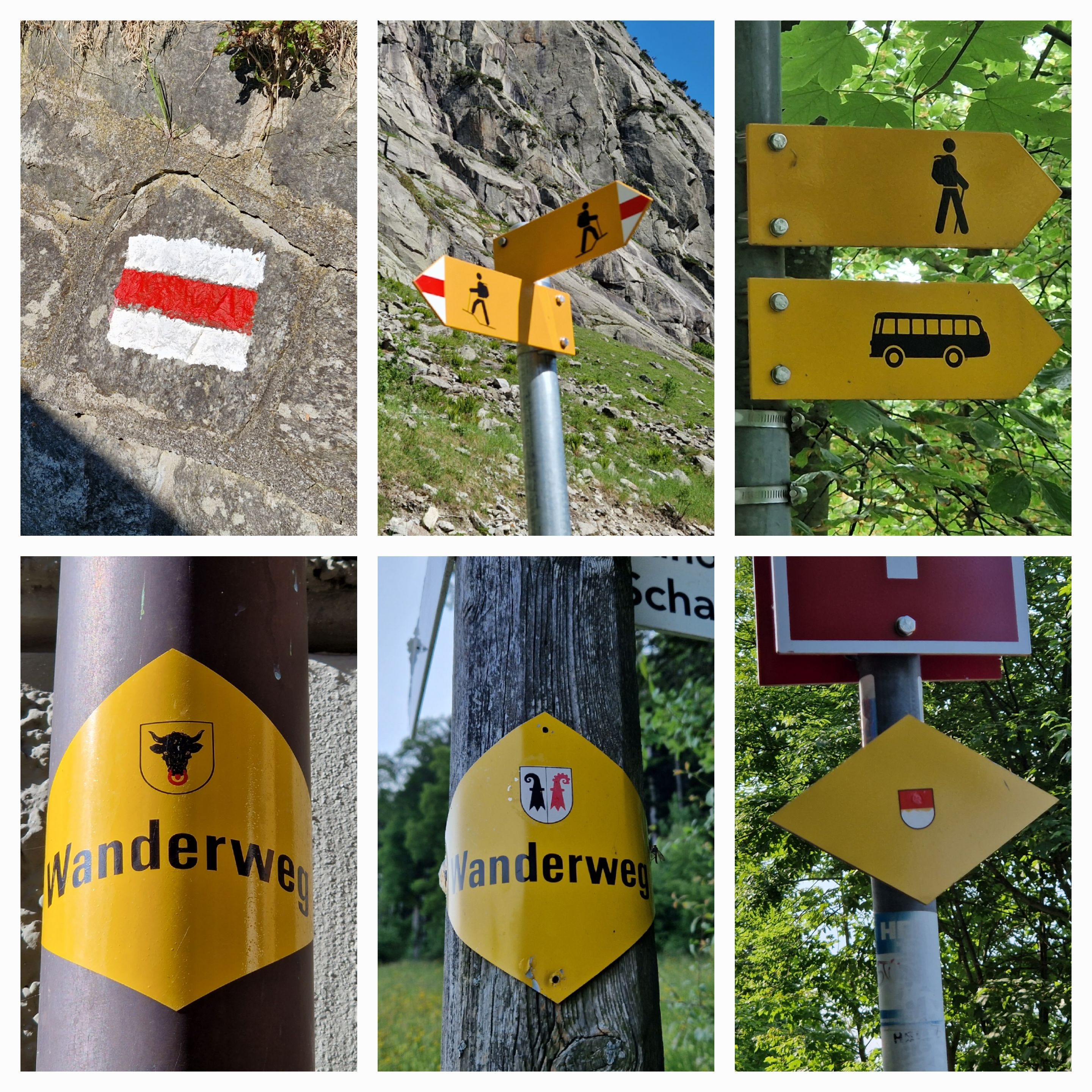
Every canton marks their hiking routes with the flag of their canton. These one’s here are Uri, Basel and Solothurn. Now, if you look at Basel there are two cantons, but they decided to work together when it comes to hiking routes. Note that the mountain hiker is walking uphill on the signs while the regular walker is more relaxed. You will also always have signs to the closest bus stop or train station.
Useful Apps & Emergency numbers
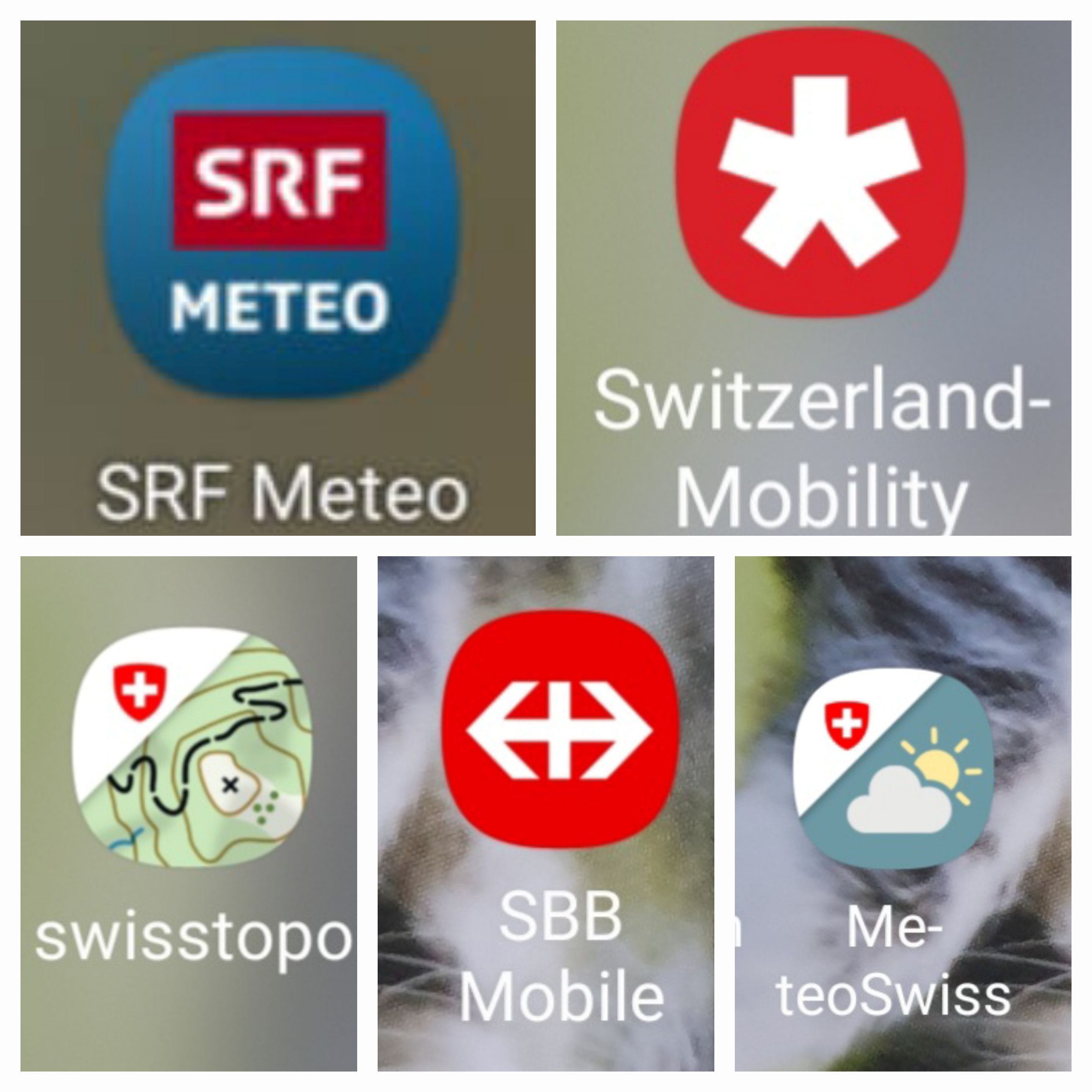
I use two different weather apps (SRF Meteo and MeteoSwiss), only got soaked once while hiking along the river Rhine. The thunderstorm hit a few hundred yards closer than expected. For public transport you should use the SBB Mobile app. Depending on where you hike it might be a good idea to check train/bus schedules before you head out. I usually check about 20 mins before the end of a hike. I mostly walk where there’s at least one connection an hour. For general topographic maps I use Swisstopo – excellent when you have a *are we there yet* moment and need to know how much higher up you need to go. My route is one of the special ones available on the Switzerland Mobility app. They also have all other routes on there, but mine is described and you have the different stages etc. in there as well. All these apps are available in English.
Emergency numbers
In Switzerland we have different numbers for different emergency services, but there is also a general number you can use. It’s 112. This one could be crucial if you are out of cell phone range - as you well might be at some point. It also uses the army and SBB mobile network, so you should be able to get through on that one pretty much anywhere.
112 – general emergency number
144 – ambulance
117 – police
118 – fire department
Videos
I’m posting videos with pictures of my hikes on my YouTube channel. Happy hiking and stay safe out there.
Notes:
Switzerland Mobility
https://schweizmobil.ch/en/summer
National routes
https://schweizmobil.ch/en/hiking-in-switzerland/national-routes
Swiss Alpine Club
Route requirements
Swiss hiking routes (not available in English)
https://www.schweizer-wanderwege.ch/de/
Their YouTube channel
https://www.youtube.com/@SchweizerWanderwegeSuisseRando
Swiss maps
https://map.geo.admin.ch/en
My YT channel
https://www.youtube.com/channel/UCPDsiwiT6TtTlj42ctZMATQ
Substack article on walking
https://evelyne.substack.com/p/why-i-love-walking-in-switzerland
The Swiss have prepared for hikers to enjoy the outdoors very effectively! The signs are fascinating and so different from anything in the USA. Looking forward to those YouTube videos. Do you encounter fellow hikers vacationing from other countries or primarily Swiss citizens enjoying the beautiful scenery?